 |
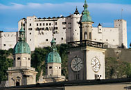
 Hohensalzburg
Fortress is the largest completely conserved medieval fortress in
central Europe. It always had a reputation for being invincible and this
proved to be such a deterrent that it was seriously besieged only once.
It was never taken. It served not only as a refuge for the Salzburg Archbishops
but they also took pride in its generous expansion with the rich profits
from the salt and gold mines. The Princes' Hall and the ,Golden Chamber"
bear witness to these riches today. Looking south from the fortress you
can see the next section highlight of the Arno Trail, the Untersberg mountain. Hohensalzburg
Fortress is the largest completely conserved medieval fortress in
central Europe. It always had a reputation for being invincible and this
proved to be such a deterrent that it was seriously besieged only once.
It was never taken. It served not only as a refuge for the Salzburg Archbishops
but they also took pride in its generous expansion with the rich profits
from the salt and gold mines. The Princes' Hall and the ,Golden Chamber"
bear witness to these riches today. Looking south from the fortress you
can see the next section highlight of the Arno Trail, the Untersberg mountain.
Back to the map |
 |
 The
wooden slides in the Dürrnberg salt mine are very popular with visitors
today. In earlier times, they provided a fast access for miners to the
adits. Many archeological findings are proof that salt was mined here
already in Celtic times. The Archbishops rediscovered the Dürrnberg salt
as a source of wealth only around 1200. Adits were cut into the salt-carrying
rock, large cavities were dug and filled with water. After three weeks,
the brine was piped down to large heating vessels. The water evaporated,
the salt remained. Salt mining was discontinued in 1989 but the historical
buildings on the Pernerinsel in Hallein are still in existence.
The old mining path up to the Dürrnberg is today a part of the Arno Trail. The
wooden slides in the Dürrnberg salt mine are very popular with visitors
today. In earlier times, they provided a fast access for miners to the
adits. Many archeological findings are proof that salt was mined here
already in Celtic times. The Archbishops rediscovered the Dürrnberg salt
as a source of wealth only around 1200. Adits were cut into the salt-carrying
rock, large cavities were dug and filled with water. After three weeks,
the brine was piped down to large heating vessels. The water evaporated,
the salt remained. Salt mining was discontinued in 1989 but the historical
buildings on the Pernerinsel in Hallein are still in existence.
The old mining path up to the Dürrnberg is today a part of the Arno Trail.
Back
to the map |
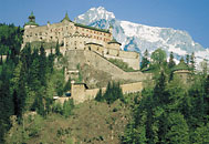 |
 The
spacious and formidable Hohenwerfen Fortress towers high above
the Salzach valley. It was established in 1077 by Archbishop Gebhard to
protect the nearby Lueg Pass. A tour of the fortress takes you to the
historical rooms and offers spectacular views over the Salzach valley.
The fortress also houses a falconry with daily flight demonstrations and
frequent special programs such as a historical hunting party or performances
of court and hunting music. From here, the Arno Trail leads westwards
along the base of the Hochk6nig range. The
spacious and formidable Hohenwerfen Fortress towers high above
the Salzach valley. It was established in 1077 by Archbishop Gebhard to
protect the nearby Lueg Pass. A tour of the fortress takes you to the
historical rooms and offers spectacular views over the Salzach valley.
The fortress also houses a falconry with daily flight demonstrations and
frequent special programs such as a historical hunting party or performances
of court and hunting music. From here, the Arno Trail leads westwards
along the base of the Hochk6nig range.
Back
to the map |
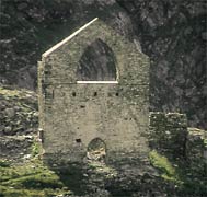 |
 From
the former gold sluice in Kolm-Saigurn at the head of the Rauris valley,
the 1500 m long Goldberg mine car led up to the wheelhouse at 2161 m altitude.
It was driven by a water wheel with a diameter of 11.5 m which was fed
by glacier runoff. The wheelhouse (shown) is one of the many points of
historical interest on the Tauern Gold Circular Trail to which the Arno
Trail leads you. The mining code issued by the Archbishops in 15553 chronicles
the gold mining boom. At that time, 2000 miners produced almost 10% of
the world gold output from the Tauern range in Rauris and Gastein. Today,
you can still try gold panning near the Bodenhaus inn; here, the at the
beginning of the Miners' Trail is also your point of access to the Arno
Trail. From
the former gold sluice in Kolm-Saigurn at the head of the Rauris valley,
the 1500 m long Goldberg mine car led up to the wheelhouse at 2161 m altitude.
It was driven by a water wheel with a diameter of 11.5 m which was fed
by glacier runoff. The wheelhouse (shown) is one of the many points of
historical interest on the Tauern Gold Circular Trail to which the Arno
Trail leads you. The mining code issued by the Archbishops in 15553 chronicles
the gold mining boom. At that time, 2000 miners produced almost 10% of
the world gold output from the Tauern range in Rauris and Gastein. Today,
you can still try gold panning near the Bodenhaus inn; here, the at the
beginning of the Miners' Trail is also your point of access to the Arno
Trail.
Back
to the map |
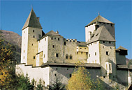 |
 Mauterndorf
Fortress was built on the second most important trading route across
the eastern Alps. In the 16th century, at the high point of the transalpine
trade between Venice and Salzburg, around 3,500 tons of goods were transported
through Mauterndorf. Before the narrow road which is part of the Arno
Trail today was completed in 1520, packhorses carried loads of 168 kilograms
each across the Katschberg and the Radstädter Tauern. The fortress was
not just an important toll station but in the late Middle Ages also the
hunting castle of the Salzburg Archbishops. Mauterndorf
Fortress was built on the second most important trading route across
the eastern Alps. In the 16th century, at the high point of the transalpine
trade between Venice and Salzburg, around 3,500 tons of goods were transported
through Mauterndorf. Before the narrow road which is part of the Arno
Trail today was completed in 1520, packhorses carried loads of 168 kilograms
each across the Katschberg and the Radstädter Tauern. The fortress was
not just an important toll station but in the late Middle Ages also the
hunting castle of the Salzburg Archbishops.
Back
to the map |